Someone had the bright idea to do the Dunk Island trek
Luckily we did not read the tourist brochure or the sign before agreeing to do it
MOUNT KOOTALOO — 7 km return (3 hrs) Grade: moderate
From the spit, walk to the north-east end of the beach to the start of the walking tracks. This more strenuous walk winds up a steep track to the 271 m summit. Cyclone-damaged rainforest on the lower slopes allows glimpses over the island and reefs as the track ascends. On the upper slopes, the forest opens out and eucalypts emerge through the canopy. Near the summit, a short branching track leads to a lookout, which offers spectacular views over the Family Islands and nearby mainland. Near the lookout, the remains of No. 27 Radar Station, built during World War II, are slowly being reclaimed by the rainforest. The track continues around the summit, rejoining the main track and returning to the beach. ISLAND CIRCUIT - 9.2 kilometres (3 hrs) Grade: moderate
From the spit, walk to the north-east end of the beach to the start of the walking tracks. Mt Kootaloo, you’ll pass through the magical Palm Valley and then onto Coconut Beach. Not for the faint hearted, this challenging walk will introduce you to Dunk Island’s lush green rainforest where you are likely to encounter the many different species of birdlife.

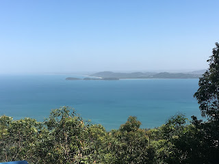
Once you get to the top of Mount Kootaloo you are rewarded with some magnificent views


And the remains from the WWII radar station - the troops had to make this trek every day


At the end of the walk you come out on Coconut Beach which has some interesting rock formations along with a washed up mooring buoy from a really big boat.


And where else can you enter restricted air space and not get into trouble
